| HOME | | | Overview | | | The Team | | | About | | | Newsletter | | | Contact | | | Links | | | Friends | | | The Novers | | | Benson Hydro | | |

|

|
The Novers Forest Garden Project | Geological Notes
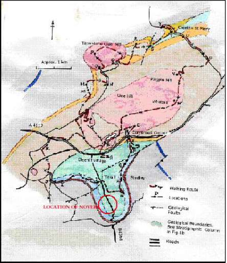
The limestone at The Novers is part of an outlier of the Carboniferous Period which forms the Clee and Titterstone Clee Hills.
The outlier, which is surrounded by much older rocks, is some 13 kms long and 3 kms wide.
The strata are gently downfolded into a synclinal structure with an axis trending NE to SW. The limestone at The Novers and the underlying pinkish conglomerate lie at the base of the Carboniferous series on the southern flanks of the outlier. This lower sequen ce of Carboniferous Limestone is well developed [up to 45m thick] between the villages of Farlow and Oreton situated on the NE edge of the outlier. Consequently these limestones and those to the south of the outlier are known as the Oreton Limestone.
The limestones are not present around the full periphery of the outlier, in some places they are faulted out and to the NW they are absent - either never have been laid down or deposited and subsequently eroded. A simplified geological map and schematic NS geological cross section of the outlier are given below.
The Carboniferous sequence is remarkable here in having representative strata from the Lower, Middle and Upper Carboniferous Period [Oreton Limestone, Combrook Sandstone formation and Coal Measures, respectively] all lying within about 1.5 km of The Novers site. In addition there is a spectacular sill of igneous rock intruded into the Coal measures. This olivine dolerite is known locally as the Dhustone (from the Welsh 'black' stone). The sill forms a capping to the Clee and Titterstone Clee Hills.
The Coal Measures were particularly important as far as activities at The Novers were concerned in that they supported a working coalfield until the 1920s. They were thus a source of coal for the limekiln. The Coal Measures strata were also worked for ironstone. There were several iron smelting works in the area and limestone from The Novers and adjacent quarries would have been used as a smelting flux.
Figutre 4
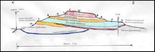
The Oreton Limestone at The Novers appears to be 25 -30m thick. At the site it overlies a basal Carboniferous conglomerate which in turn rests on Silurian strata
[Downtonian Series], the expected intervening Devonian Period ro cks are absent. This represents a gap in deposition [an unconformity] of some 60 million years. However to the NE of the outlier in the Oreton and Farlow areas the Devonian rocks are present and the Oreton Limestone lies on Upper Devonian strata [see figur es below].
During the Upper Silurian and Devonian periods, about 350 million years ago, this part of Shropshire was on the southern shores of a continental land mass south of the equator. Deposits of gravels, sands, silts and muds were formed in braided r ivers cutting through, or building up, large deltas and in shallow lakes. With time these deposits became conglomerates, sandstones, siltstones, mudstones and shales. These rocks are greenish, purple or red in colour and are known as the Old Red Sandstone. The red colour of the soils in the fields immediately to the south of The Novers advertises their presence.
At times during the formation of the Old Red Sandstone the climate was relatively hot and this led to the formation of calcretes where evaporation brings calcium carbonate and other minerals to the surface. Leaving them as a natural lime cement and building up over time to form a thin limestone. Calcretes are being formed under similar desert conditions today. At the end of the Silurian such a pron ounced rubbly limestone was formed and this is widespread across this area of Shropshire. It is called the Psammosteous Limestone and is considered to be the boundary between the Silurian and Devonian periods.
It is about 2-3m thick and in the past has been extracted from shallow workings at a number of sites around the Clee Hills. Such excavations can be seen near Hints, about 2km to the east of The Novers. Pieces of the limestone can be found in the old works. That it was considered worthwhile to extract these thin limestones indicates what a valuable resource the limestone was and how important the much larger quarries at The Novers and adjacent areas must have been to the regional economy.
At the end of the Devonian period this area of Shropshire was inundated by a warm, shallow, clear sea, teaming with life. Limestones were built up on the sea floor from fragments of many shells, crinoids and corals. Fossil remains of these creatures can be found in the Oreton Limestone at The Novers. During this form ation about 350 million years ago the area was located close to the equator however, as a result of shifts in the earth's tectonic plates since then, it has moved progressively northwards to its present position.
The Oreton Limestone appears to have been formed on the southern margins of a landmass [St George's Land] which extended east to west across the Midlands. The limestone, which is Tournaisian in age, appears to have more in common with the much thicker Carboniferous Limestones to the south [S.Wales , Bristol, Mendips] than those to the north [N.Shropshire, Derbyshire, N.Pennines]. It is informative to contrast the appearance of the marine Oreton Limestone at The Novers with the terrestrial Psammosteous Limestone at Hints.
A fall in sea level or a rising land surface led to the build up of a thick succession [approx. 210m] of conglomerates, grits and sandstones on top of the Oreton Limestone. These sediments, formed under deltaic conditions, are known as the Combrook Sandstone Formation. They are present at The Novers and extend over
much of the area to the north. Because the strata contain only a few fossils there is some doubt about their age. They probably equate to the Millstone Grit in the lower part of the sequence and the younger Coal Measures in the upper part.
The deltaic conditions that led to the formation of the Combrook Sandstones were followed by swampy rivers, floodplains and lagoons, at times carrying a rich vegetation with large trees and ferns. During this period sea level rose and fell many times leading to the deposition of a repeated sequence of sands, muds and coal [from the vegetation] which formed the Coal Measures. In the Clee area there are four principal coal seams ranging from 2 -6ft in thickness. The shallow coals have be en worked in 'bell pits' since mediaeval times and the deeper coals have been mined using more modem methods until the 1920s. At the end of the Carboniferous period the igneous sill was intruded into the Coal Measures due to volcanic activity.
Figure 5
During the most recent Devensian glaciation which ended about 11000 years ago massive glaciers occupied the Welsh hills and extended over the Cheshire plain as far south as Bridgnorth but the high ground of the Clee and Titterstone Clee Hills was not glaciated. However there is ample evidence of frost action splitting the hard dolerite and releasing large boulders which can now be found on the lower slopes of the hills.
It is evident that a wide variety of 'geological environments' can be discerned by inspecting the rocks at The Novers and within 1 -2 km of this site. These include: hot desert conditions, warm sunlit seas, marine deltas, swampy lagoons with luxuriant vegetation, volcanic activity and arctic conditions. Because of the many interesting geological features present in a relatively small area the Carboniferous outlier and its environs is an attractive location for amateur, student and professional geologists alike.
The Shropshire Geological Society has recently published a walkers' guide to the area [ref]. This does not include The Novers because of access limitations. However, improved access to The Novers, with its wonderful limekilns and unique tunnels, would add greatly to an appreciation of the intimate association between local geology and industry.
The old limestone quarry faces are overgrown but it should be possible to remove vegetation over a narrow section to reveal the limestone face and in particu lar the contacts with the overlying Cornbrook Sandstone, the underlying Basal Conglomerate and the Old Red Sandstone. Such contact features are important in the interpretation of local geology but cannot be seen readily elsewhere across the outlier. If the tunnels could be safely opened they should give an insight into any local faulting and lead to a better understanding of the geological structure of The Novers and beyond.
The Novers should not be seen as a 'stand alone' feature but as a key enabling a weaving together of a whole range of geological threads. In this respect it should be considered in relation to the 2004 - 2009 'Titterstone Clee Hill Geodiversity Management Plan' and the 2008 Conservation Plan for the Historic Mining & Quarrying Landscape of Titterstone Clee.